Moab: Home to Arches, Canyonlands, and Westworld

When I chose Moab, Utah as our weekend destination after a work trip to Las Vegas, I didn’t know a whole lot about it. I knew that Moab was home to Arches and Canyonlands National Parks, that it was a larger town than Springdale, Utah (the gateway to last year’s destination, Zion), and that January was definitely Moab’s off season.

It wasn’t until after I settled on Moab that I realized I could run a race while I was there AND that the valleys, canyons, and vistas surrounding Moab were where HBO’s Westworld was filmed.  Running races and Westworld are two of my favorite things, so I was pretty sure that I was going to LOVE Moab!

Here’s our Moab trip in map form. Click here to view a larger map and click on a waypoint to view a photo.

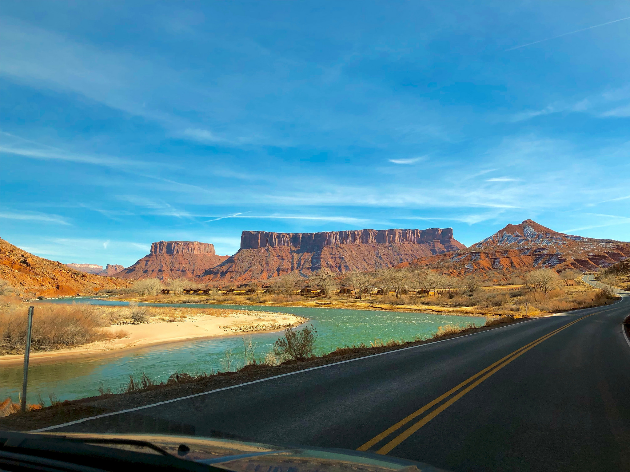
After I finished the Arches Ultra 9K on Saturday morning, Matt and I began exploring Moab. We drove along the Colorado River on Route 128, admiring the steep cliffs and bright blue water. For Westworld fans, this road is the “track” that the train takes to enter the park. There are no actual train tracks here, so they built a train car on the back of a flatbed truck and drove up and down Route 128 during filming. Matt and I listened to Westworld’s theme song on repeat during this section of the drive.

We soon came upon Castle Valley and Fisher Towers, two more show locations. We spent the afternoon hiking around Fisher Towers, then drove through Castle Valley before retracing our route back towards Moab and then north towards Canyonlands. We watched the sun set as we drove towards Canyonlands’ “Island in the Sky” mesa, then turned around and headed back to town for the night.

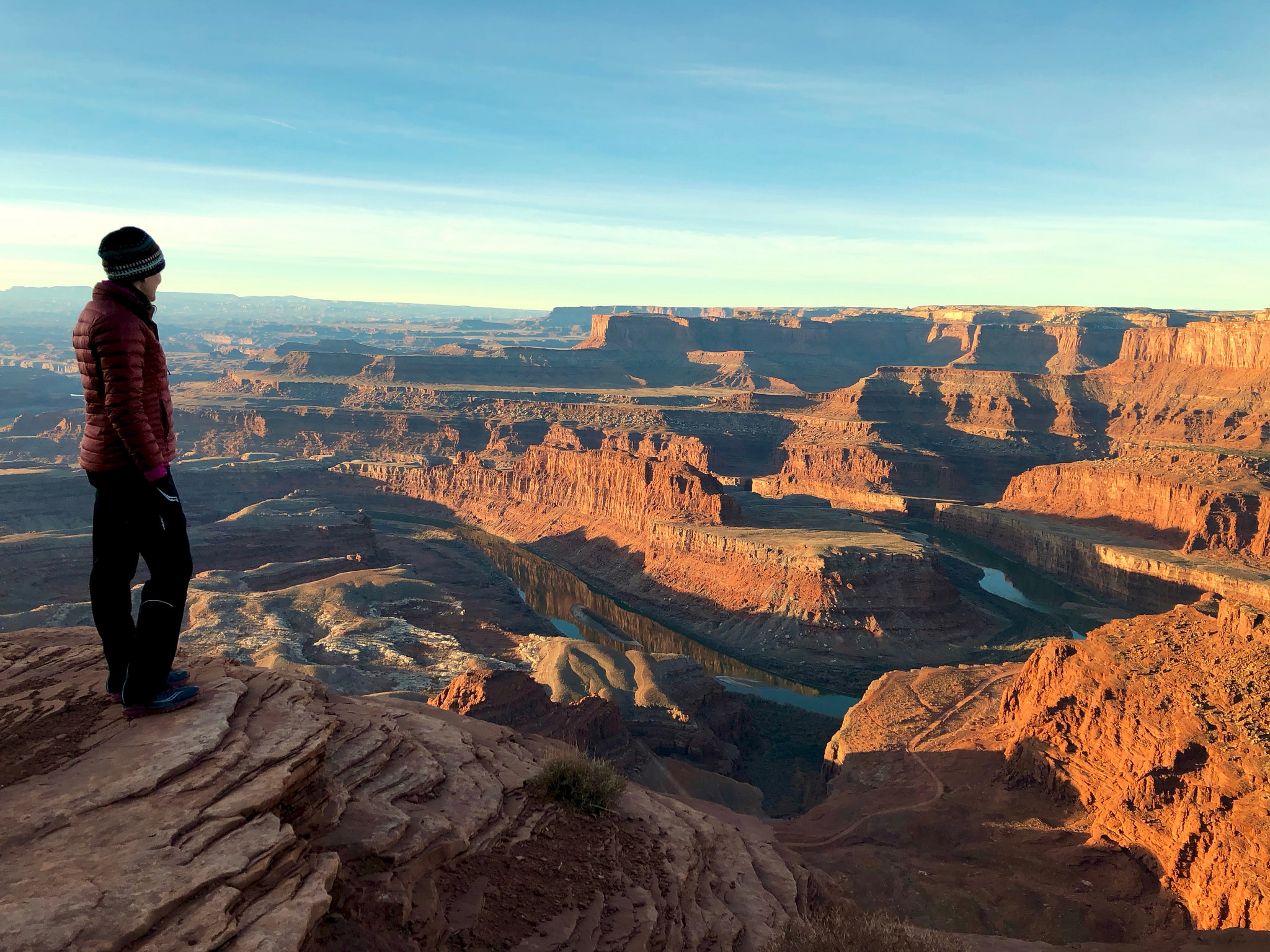
On Sunday morning we woke up early and drove for 45 minutes in the dark back up to the Island in the Sky. We paid $15 at an unmanned kiosk to enter Dead Horse Point State Park, then made our way to the Dead Horse Point viewpoint to watch the sun rise.  It was cold (25°F), quiet and beautiful. We looked out over rugged red cliffs and canyons that stretched as far as we could see and watched the January sun beams slowly illuminate the scene, turning each rock face they reached an intense, fiery red.

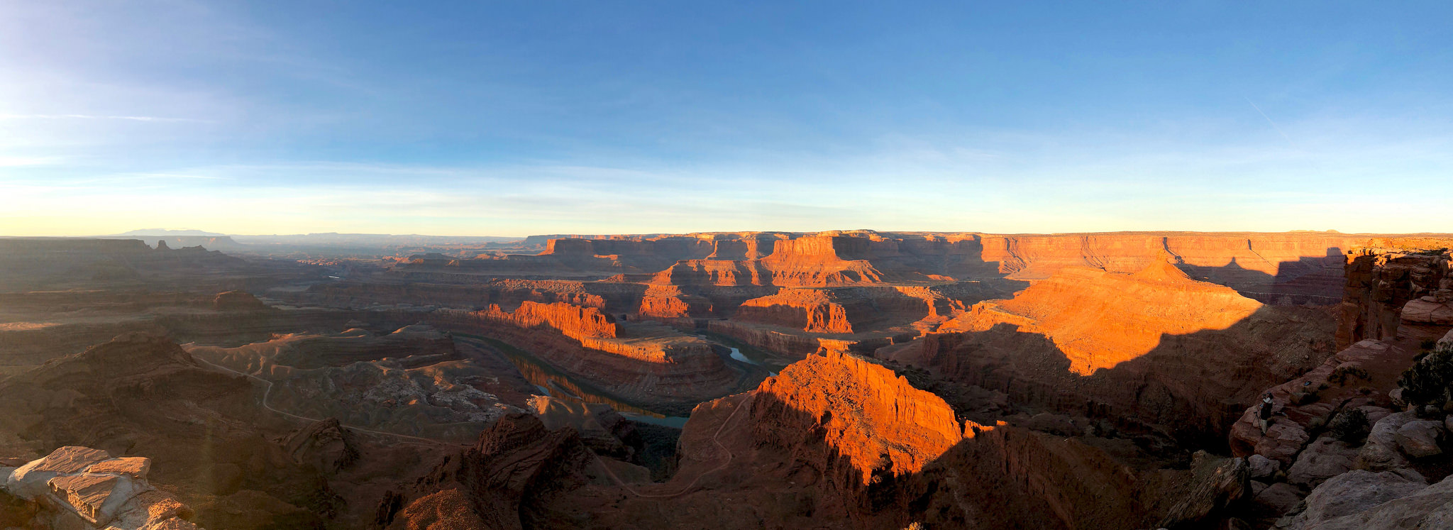
We shared this experience with one other couple and three professional photographers who had set up their tripods on a cliff below us.  It was so quiet we could hear the shutters on their cameras clicking as they snapped shot after shot of the amazing view. Once the pros were done we walked down to the same spot and took a few of our own photos. Views don’t get much better than this.

For Westworld fans, Dead Horse Point is a show location that’s featured in Episode 1. Look familiar?

Next we entered Canyonlands National Park and took a quick hike to Mesa Arch… our first arch of the trip! It did not disappoint.  We had Mesa Arch to ourselves and the underside of the arch was glowing in the early morning sun.

We returned to Moab for a quick breakfast (and much needed coffee… I was really dragging after our pre-dawn wake up call!) and then set our sights on Arches National Park. Arches is a fairly small park with a single main road that allows you to get close to many of the major highlights with minimal hiking required.  We hit several of these spots on Sunday, with visits to Balanced Rock, North Window Arch, South Window Arch, Turret Arch, and Double Arch.

Next we embarked on a longer hike to see Utah’s famous Delicate Arch. I was a little worried that this arch might not live up to its hype… how could it possibly compare to our transcendent sunrise from 8 hours earlier??! Matt and I hiked up smooth red rock for a mile and a half and carefully picked our way along an icy trail that was little more than a ledge on the shaded side of a red cliff face. This was the most crowded hike we’d been on so far and I was just starting to get tired of watching people in inappropriate footwear try to navigate the ice when we turned a corner and there it was: DELICATE ARCH.

Delicate Arch was breathtaking. The scale of it is hard to describe. It looks small at first, but then it dawns on you that the little speck at its base is a person and you realize how big it is, and how stately and alone it is, just standing there, rising up out of the red stone and framing a gorgeous range of snow-capped mountains off in the distance. All of the other hikers around us were clearly hit with the same emotion, and we all just sat down with our backs against a warm rock wall, murmuring quietly amongst ourselves and staring at Delicate Arch in the afternoon sun.

Matt and I stayed at Delicate Arch for close to an hour before heading back down the mountain. Delicate Arch totally rivaled Dead Horse Point’s sunrise views and I would strongly recommend both spots to any future Moab visitor.

Monday was our last day in Moab and we had a long list of arches that we still wanted to see. Matt and I got on the road in the dark once again, this time heading to the Devil’s Garden section of Arches NP. Devil’s Garden is home to a staggering number of arches and other crazy rock formations, including Landscape Arch, the longest natural arch in the world.

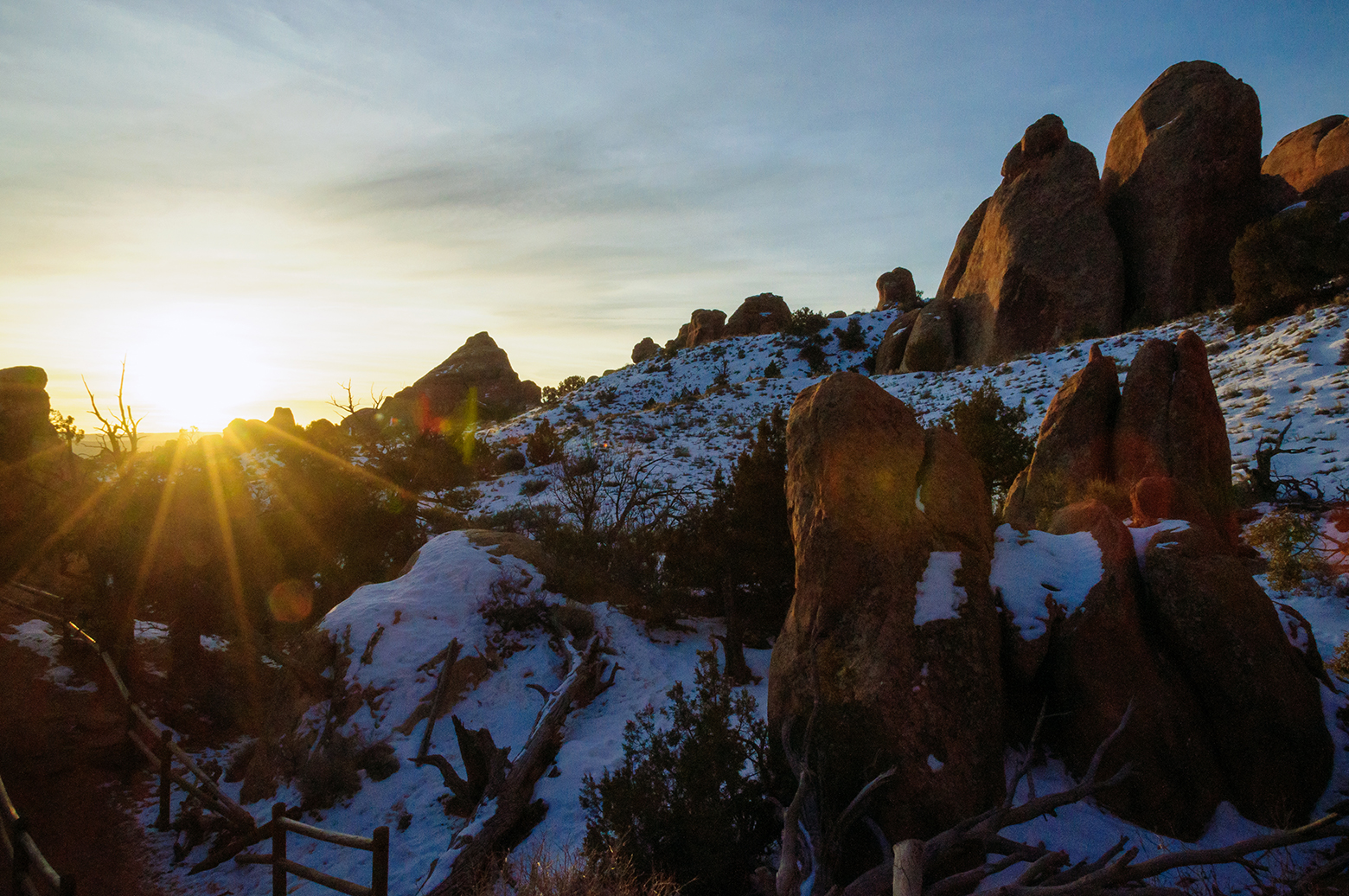
We hiked on the snow-covered trail in the dark and arrived at Landscape Arch just before sunrise. There were no other people in sight, just us and the long, unbelievably thin arch. We watched the sun hit the arch, turning it a bright golden yellow, and took tons of photos. Then we left Landscape Arch behind and set out on the “primitive trail” to see more of Devil’s Garden.

The primitive trail was barely a trail in most places. It was good that the sun was up by this point, because we had to climb and scramble up, over and across rock fins and ridges to get to the next few arches on our list. In one area we had to walk along an exposed rock spine with drop offs on either side and a steady, strong cross wind… so powerful that when I took my glove off to take a photo and I had trouble putting it back on because it was blowing straight sideways.  Luckily my earwarmer headband was holding my precious Arches Ultra cap securely on my head!!

While in Devil’s Garden Matt and I saw Partition Arch, Navajo Arch, and Double O Arch, then returned back by Landscape Arch to visit Tunnel Arch and Pine Tree Arch. There was one other couple out on the primitive trail but we otherwise had this sunrise hike to ourselves.

Next we took a few short hikes to Skyline Arch, Sand Dune Arch and Broken Arch (all “private” viewing again… January is definitely the time to visit Arches!!) and then we wrapped up our long morning of hiking with a trek down “Park Avenue,” a canyon lined with towering rock monoliths that reminded early visitors of a skyscraper-lined street in Manhattan.

We returned to Moab for lunch at the Moab Brewery. By this point Matt and I estimated that we had hiked close to 10 miles but we weren’t done yet. After lunch we made a quick stop at the nearby Matheson Wetlands Preserve, a natural wetlands area on the Colorado River. The preserve was underwhelming, with little wildlife out on a chilly January day, but it was a quiet place to digest our beer and burgers before our final hike of the trip.

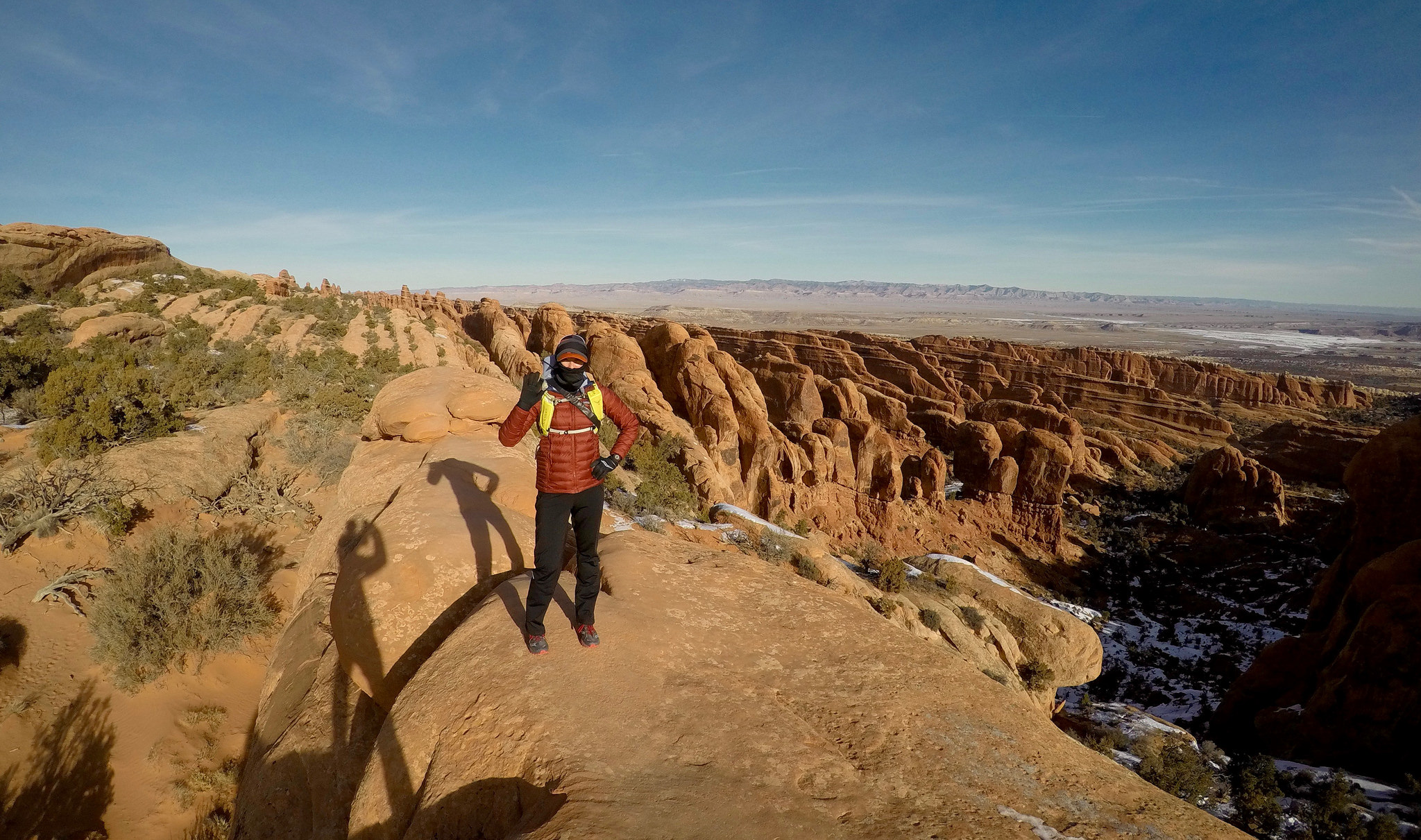
To get to our last hiking destination we had to drive along Route 279 (aka Potash Road), a scenic road sandwiched between the Colorado River and sheer red cliffs. The cliffs are home to “Wall Street,” a popular rock climbing area, as well as several great examples of historic Indian rock art. We stopped to see the petroglyphs before continuing on to the Corona Arch trailhead.

The Corona Arch parking lot was almost empty, and we passed the afternoon’s only other hikers on their way back to their car less than a mile into our hike. Excited to have one more arch all to ourselves, Matt and I pressed on, climbing up and up into a wide bowl-like formation with steep drop offs to our right. We scaled a ladder bolted to the rock and trekked up stone steps carved into the rock.

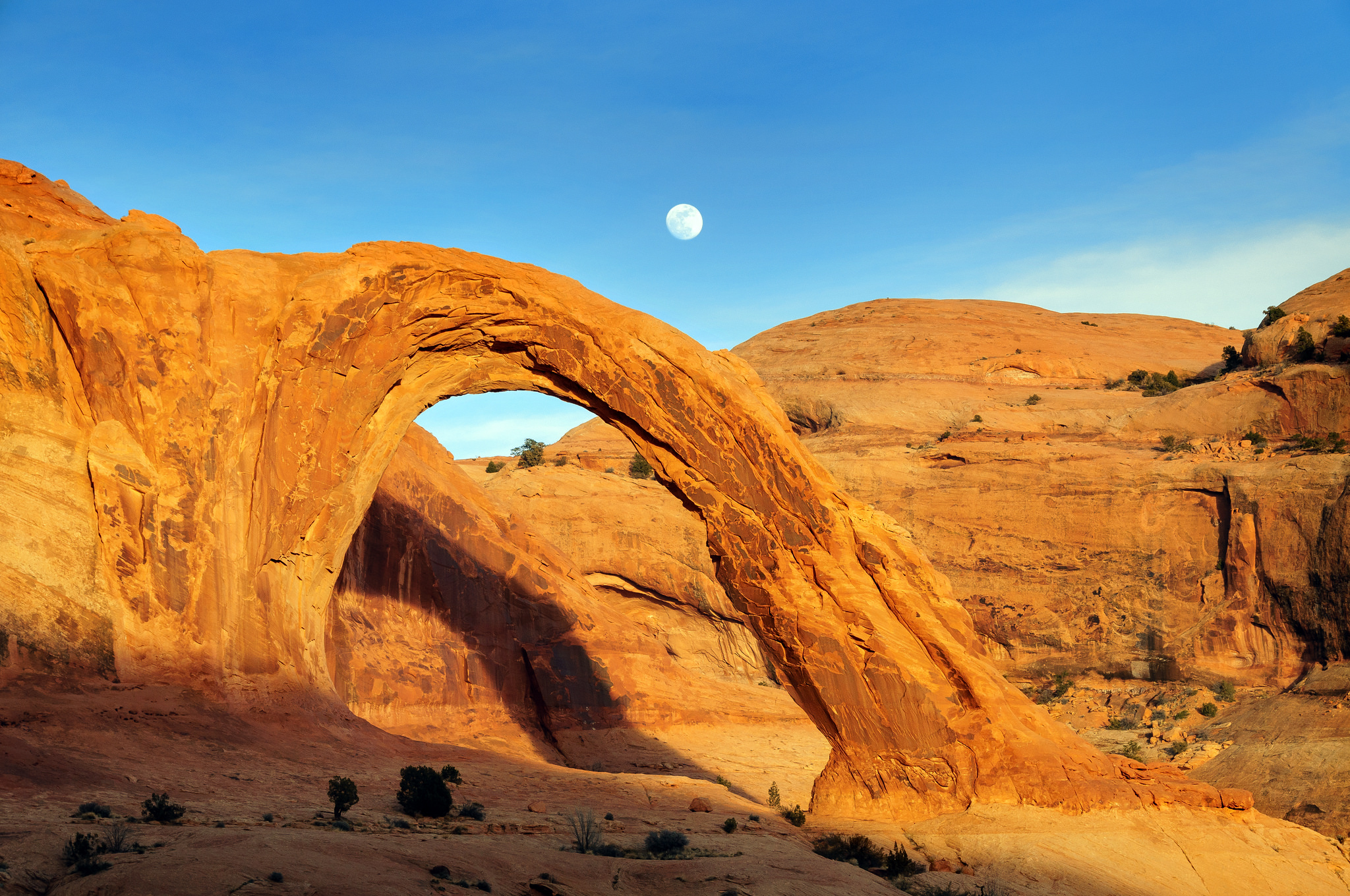
Finally the massive Corona Arch came into view. Once again, we had a private viewing of the breathtaking arch, and we spent a while soaking in the view and utter silence around us. Just as we were about to head back to the car the nearly full moon (the super blue blood moon) rose up and over the arch. Perfect.

And just like that, our whirlwind weekend in Moab was over. We were on the road by 4:14AM the next morning and back in Philadelphia nine hours later.

In three days we hiked to sixteen arches, visited two National Parks, saw magnificent views of the Colorado River, and were outside (or in the car) for every sunrise and sunset. Best of all, we experienced all of this with no crowds and, in most cases, with these iconic landmarks all to ourselves. Moab in January definitely did not disappoint!

Climbing Old Rag Mountain

Over the past three years Matt and I have hiked and road-tripped our way through some awe-inspiring destinations on the west coast including Zion National Park, Sedona and Big Sur. Traveling “Out West” has become a yearly pilgrimage, yielding beautiful memories from past adventures and unlimited possibilities for future trips. (Portland! Napa! A train ride from SF to Chicago! The Grand Canyon! So much to see.)

With all of that excitement happening on the left coast, I haven’t given much thought to potential trips back east.  Sure, we take annual drives to the Poconos and the beach and make our way up to Vermont or northern New York every once in a while, but none of these places have rivaled the awesomeness of the western landscape. But all that changed on Friday when Matt and I hiked up Old Rag Mountain in Virginia’s Shenandoah National Park. Continue reading

That time Piper met a Porcupine…

Flashback to last Saturday morning. Matt and I are sitting next to an older man in the Emergency Vet’s waiting room watching a nature show on TV. A porcupine appears onscreen and the man says “Have you ever seen a dog that came face to face with a porcupine?? OUCH!” Oh yes, I tell him. In fact, that’s exactly why we’re here!!!

Piper, or Porcupipe, as she may be called from now on, BIT A PORCUPINE on Friday afternoon. Piper is fine and no, I don’t think that she learned not to mess with porcupines in the future!! We were on a hike as part of our annual sojourn to the Hunting Camp, aka Globe Run Rod and Gun Club, a private wilderness retreat located in Huntingdon County, Pennsylvania.  As is always the case at Camp, all dogs run free and daily activities include swimming in the lake, hiking, and logging some quality time in the rocking chairs on the front porch. But this year was a liiiittle different, thanks to Piper’s prickly new friend. Continue reading

Let it snow! Long enough for a run, at least.

We experienced some very odd weather in southeastern Pennsylvania yesterday… it snowed! And not just cute little spring flurries. This was real, accumulating, white-out conditions SNOW! The storm started mid-morning and dumped 4-5 inches on my daffodils, budding trees, and sugar snap pea shoots. There was nothing I could do to protect my garden so I decided to take Piper out for a trail run at nearby Okehocking Preserve instead.

Okehocking Snow Run

We ran a big loop around the preserve, enjoying the muddy trails, slippery hills and snowy grass. This might have been a freak storm, but it sure was pretty!

Okehocking in the Snow

I brought my Go Pro along and had fun running towards it on the trail. Matt gave me the Go Pro for my birthday last November and I’m still learning how to take advantage of the tiny camera’s super wide-angle lens and various shooting modes. Yesterday I played around with the Go Pro’s continuous photo mode and tried to avoid stepping on it each time Piper and I zoomed by.

Luckily no one else was out in the storm to witness this behavior… Piper thought we looked pretty silly.

Look at the camera, Piper

The storm ended at 5PM and immediately started melting. Our backyard is still blanketed in snow more than 24 hours later, but the temperature is supposed to rise to 62°F tomorrow so the snow should disappear soon. As much as I enjoyed my winter romp with Piper, I’ll be OK if I don’t see another snow flake until November!!

Okehocking Preserve (4/9/16)

It only took me 16 days… 2015 Recap and 2016 Goals!

This morning it was my turn to take Piper out.  Usually I have no trouble falling back to sleep after our chilly 7AM tour around the yard, but today I felt especially awake and decided to catch up on some long overdue blog reading.  I scrolled through my WordPress “Reader” for nearly an hour and thoroughly enjoyed reviewing the many year end recaps and ambitious 2016 resolution posts that bloggers I follow wrote 2+ weeks ago.

All of this inspirational reading served to remind me that I’ve been terrible about updating my blog lately.  I’m not sure why that is,* but whatever the case, I’m not going to beat myself up about it.  The whole point of my blog is to document the races, foods, trips and other events that I’m enjoying and if nothing “blog-worthy” happens for a few weeks, so be it!

(*OK, I’ll confess: My recent lack of posts is almost certainly because we’re binge-watching Sons of Anarchy.  It’s so riveting that I can’t multi-task and blog while watching it!)

Although it’s January 16th, my morning reading has inspired me to offer my own 2015 wrap up and 2016 goals.  Without further ado, here I go!

2015 was the year of the mini-vacation.  Matt and I traveled to 10 states and spent 28 nights away from home.  Piper joined us on several trips and spent the other nights slumber-partying at my mom’s house with her best friend, Hershey the Chocolate Lab.  Matt and I primarily traveled within driving distance, but also flew to Vegas for work at the beginning of the year and then to California for an epic drive up the Pacific Coast Highway in October.

Since 2015 marked another year of my ongoing mile-a-day streak, I began nearly all of my out-of-town mornings with a run.  This was a great way to feel good on vacation AND get a feel for my surroundings, regardless of whether I was in a big city, little town, or remote forest.  In 2015 I ran in places as diverse as Las Vegas (NV), Cape Charles (VA), Bethany Beach (DE), Avon-by-the-Sea (NJ), Skaneateles (NY), Promised Land (PA), Dorset (VT), and Carmel (CA).

When I wasn’t traveling, it seems like most weekends were spent racing.  In 2015 I completed 27 races and earned 7 new personal best times (1-2M, 2-5K, 1-5M, 2-10K, 1-10M).  The year finished surprisingly strong with 3 PRs in a row at 3 different distances.  I guess I did something right in 2015?!

And about that streak… I’ve now been running, hiking, or otherwise moving my body a mile a day every day since July 2013. My daily miles are now a completely routine part of my life and are just something I do, like eating or brushing my teeth.  As of today, I’ve been streaking for 930 days and 4,380.5 miles with no plans to stop anytime soon.

Looking ahead to 2016, I hope to continue many of the same habits, including trying to pack as many mini-getaways into our busy lives as possible.  Matt and I already have a weekend trip to Sedona, AZ planned (I am SO EXCITED!!) and I wouldn’t be surprised if we find ourselves in California, Kentucky and multiple states on the east coast at some point later this year.

One thing that will be changing for 2016 will be my total number of races.  I’m not opposed to racing 25+ times in a year, but I know I’m going to miss at least 7 of the races I enjoyed last year due to scheduling conflicts. (For example, my brother decided to get married the night before the Broad Street Run!! But I forgive him. 😀)  I’ll also miss the Athlete’s Closet Winter Series this year as the series was cancelled.  Oh well!  Racing is fun but isn’t everything… maybe I can use that time to get some extra miles in with Piper!

Running with Piper is one of my biggest goals for 2016.  She was too young to really do many pavement miles last year, plus she pulled on the leash like a maniac which made runs much less pleasant than they should have been.  In late December I finally broke down and bought her a “Gentle Leader” head collar to put an end to her pulling and so far it has worked wonders.  We still have lots of training to do, but I look forward to lots of happy runs with my little GSP this year.

My final goal for 2016 is a simple one… improve my CORE STRENGTH!  In 2015 I did exactly zero strength work, but I’m fully aware that if my abs and arms are stronger I will be a better runner, even if I don’t change a thing about how I actually train to run.

Fortunately for me, core strengthening is a goal that I can absolutely accomplish from the comfort of my living room floor while watching Sons of Anarchy.   Otherwise core strength, like my nonexistent blog posts, might never happen!

2016 Resolutions:

  1. Don’t stress out about not blogging regularly. I blog for fun and want to keep it that way.
  2. Take lots of trips with Matt (and Piper) whenever possible!
  3. Teach Piper to run with me.
  4. Improve my core strength. (Bonus goal: Teach Piper that she’s not actually helping when she licks my face during a plank!!)

Oh, and in case you were wondering, Piper resolves not to dig in my garden in 2016…

08 Piper

JUST KIDDING!!! 😄


Birthday Hike at Binky Lee

Smile, it's Friday!

Smile, it’s Friday!

A few weeks ago Matt and I took Piper hiking at Binky Lee Preserve in Chester Springs, PA. It was my birthday so Matt was extra patient when I stopped to take dozens of photos of fall foliage, grasses, and (of course) Piper. Piper was less tolerant of these numerous delays – she prefers to be moving full speed ahead at all times – but I was still able to capture a few shots of her against the gorgeous fall landscape.

Here are some photos from our hike. This really is what Southeastern Pennsylvania looks like in the fall. Isn’t it pretty??!

Oh, and in case you were wondering, this is what a German Shorthaired Pointer with a mouthful of water looks like! I think she was trying to bring some of the creek along for the rest of the hike. 😄

389 mouth fulla water

If you find yourself in northeastern Chester County looking for a place to hike I’d definitely recommend visiting Binky Lee. For more information check out the links below. Happy Friday!

Binky Lee Preserve
1445 Pikeland Road
Chester Spring, PA 19425
Web Site  |  Trail Map  |  Google Maps

455 Piper in fall

Lye Brook Falls (Manchester, Vermont)

047 Lye Brook Falls

During the last weekend of September (aka “Pope Weekend” for anyone in the Philadelphia area) Matt and I headed north to the picturesque town of Dorset, Vermont for a wedding. After a smooth 5 1/2 hour drive we arrived in neighboring Manchester at 1PM on Friday, eager to do some New England hiking before going into party mode.

We ended up doing two hikes during our short stay in southwestern Vermont. I highly recommend both if you’re in the area and feel like exploring.  Just make sure to bring good hiking shoes and a camera! This post covers Friday’s hike. Info on Saturday’s climb to Gilbert Lookout in Dorset will be posted soon!

Lye Brook Falls Hike

Trailhead: Lye Brook Falls Service Road, Manchester, Vermont (Google Maps Location)
Distance: 4.6-ish miles round trip
Trail Map: U.S. Forest Service Lye Brooks Falls Guide [PDF]
Terrain: Rocky out-and-back; gradual uphill out and downhill back
Highlight: 125 ft. high Lye Brook Falls, one of Vermont’s tallest waterfalls

I first learned about Lye Brook Falls from the US Forest Service web site. Here’s how they describe the hike:

The trail, marked with blue blazes, enters the 15,680-acre Lye Brook Wilderness following along Lye Brook. Utilizing old logging railroad grades and old woods roads, the trail travels up a steady gradual slope. Downed trees from a 1995 cyclonic storm and a few small stream crossings make some of the trail challenging, which is in keeping with Wilderness management practices. A century ago, this area had been heavily logged, with railroads, charcoal kilns, and sawmills dotting the landscape. The land has reverted back to its natural state, but those wishing to explore can still find the remains of many of these turn of the century industries. The spur trail at 1.8 miles on the right, leads to the 125-foot high Lye Brook Falls, one of the highest in Vermont. Slippery rocks make the falls extremely dangerous and climbing the falls is not recommended.

Sounds cool, right? It was! The Lye Brook Falls trail is just a short drive from the factory outlets in Manchester but (thankfully) you immediately feel like you’re in another world. The trail is well marked and the sounds of the Rt. 7 highway quickly fade away and are replaced by the babbling of Lye Brook and forest noises. (Namely chipmunks… those guys are LOUD!!) 😀

Be forewarned that the trail is extremely rocky in some areas, so good shoes are a must. The view at the falls makes all of the uneven terrain totally worth it though!

Vermont has been having a major drought so Lye Brook Falls didn’t feature a ton of rushing water, but the sheer height of the falls was very impressive. The rocks just kept going up and up and up!! When we got to the falls we initially climbed down to the bottom, but the falls were so tall that it was hard to actually see the top from way down there. We returned to the trail and climbed up for a ways which gave us a much clearer view of the waterfall. It was beautiful!

After our hike we returned back to civilization, checked into our B&B and met up with a big group of wedding guests for a late-night welcoming party. It was a great first day in Vermont!

049 Lye Brook Falls

Ridley Creek State Park Orange Trail

As I type this it is 67 degrees outside… easily the warmest day of the year!  I’m about to go on a nice, long run and I’m definitely looking forward to running in a t-shirt!!!

Before I embark on my run I want to share some photos from a hike that Matt, Piper and I took last weekend.  We explored out a different part of Ridley Creek State Park on Sunday and it was beautiful!

Ridley Creek

We typically stay on the west side of Ridley Creek but on Sunday we ventured eastward to the park’s Orange Trail.  This single track path follows the eastern bank of the creek before looping back through a hilly forest.  The trail is well marked with orange blazes and the entire lasso-shaped loop was about 2.35 miles long.

Oddly, the official DCNR map shows a shorter orange loop than what was marked in the woods, so I overlaid the outline of our actual hike on the above map.

Oddly, the official DCNR map shows a shorter orange loop than what was marked in the woods, so I overlaid the outline of our actual hike on the above map.

Piper had a blast, as usual.  She is getting very comfortable climbing on boulders, logs, dirt piles and anything else we find in the woods.  She also really wants to go in the water but it’s still pretty cold out so we still haven’t really let her get more than her paws wet.  I can’t wait for warmer weather!!

All in all this was a pleasant little hike with great views of the creek.  I’ll definitely return to the Orange Trail, maybe for a run or a summer picnic by the water.  Piper still doesn’t even know that summer exists, but soon enough she’ll see what I keep raving about! 😀

What are you looking at?

“‘Summer?’ I’ll believe it when I see it!”

Ridley Creek State Park
351 Gradyville Road
Newtown Square, PA 19073

Hiking Delaware’s New National Monument

Matt and I have gotten into the habit of taking Piper hiking nearly every weekend.  We have a few favorite spots like Ridley Creek State Park and Okehocking Preserve, but sometimes it’s fun to let our pup explore a new place.  Earlier this month when the weather was especially nice (aka not below freezing!) we decided to bring Piper to the Woodlawn Trustees Preserve.  The preserve stretches for thousands of acres on either side of the Pennsylvania-Delaware border and features miles of hiking trails, scenic sections of the Brandywine Creek and breathtaking vistas of rolling hills and woodlands.

Woodlawn Trustees Sign (2012)

Matt and I have hiked at Woodlawn several times but last weekend was our first visit since the area was officially declared a National Monument in March 2013.  With the exception of a few new signs in the parking lot the National Monument designation didn’t seem to change the area much which is good because it’s already perfect just the way it is!

Piper had a blast on our hike.  She sniffed everything, tried to convince us to let her swim in the Brandywine (it was 40° out – not happening, pup!), and confidently stared down the mountain bikers that were out on the trails in force.  She is definitely getting accustomed to me taking photos of her on hikes… sometimes I think she poses on purpose!

Piper in the winter woods

In the shot above Pipe stopped to listen to the eerie sound of a train whistle floating through the cold winter forest.  I learned afterwards that the train we heard is the East Penn Railroad (you can actually see the locomotive in the Granogue Estate photo, above) and it runs about three times a week to take steel to and from a recycling plant in Pennsylvania.  Cool!

Below Piper was pointing at some unseen (or imagined) prey.  She looks so grown up!

Piper pointing

Matt, Piper and I hiked a nice 4 mile loop that began at the parking lot on Brandywine Creek Road just south of the intersection with Smithbridge Road on the Delaware side of the border.  We finished with an easy flat mile along the Brandywine Creek.  During warmer months this is a very popular area for kayaking and canoeing but last weekend we only saw one lone canoer (canoeist?), frantically paddling upstream against the current.  I bet her arms were tired once she made it to her destination!

Piper takes a little dip in the Brandywine

If you find yourself in the southern PA/northern Delaware area on a nice day I would strongly recommend that you pay a visit to the Woodlawn Preserve.  Detailed information on the area is somewhat scattered between Woodlawn’s web site, the new National Park Service page, and an preservationist group called Save The Valley so I suggest checking out all three organizations for information before planning a day trip.  Here’s a map from Save the Valley with our 4 mile hike overlaid in red:

Woodlawn Trail Map 4 miles

Click here to view the original Save the Valley map.

When the weather gets nicer I will hopefully return to Woodlawn with a running buddy for some quality trail running.  Maybe by the end of the summer I will be running here with little Piper!  I’m pretty sure she will think that’s the best thing ever.  😃

Piper at the Brandywine

Trail Running: I’m Hooked!

Big news on the blog today… I think I’m turning into a trail runner!  It all began on January 17th when I avoided the trails and chose the easier road course at the Pickle Run.  After the race was over two Trail-Picklers cheerfully informed me that the trails were WAY more fun than the boring out-and-back road course.  They suggested that I give the trails a try in the future and I took their advice to heart.

Yaktrax Trail Run

The Sunday after returning home from Vegas I took Piper out on a walk/jog in Ridley Creek State Park to see for myself how fun this whole trail running thing could be.  I LOVED IT!! The snowy trail wound around in the woods, up hills and over little frozen creeks.  Every once in a while the trail would intersect the paved multi-use park road and Piper and I would dash across, pausing just long enough to glimpse a few road-runners before diving back into the woods on the other side.  Piper shouldn’t be running any significant distance yet since she’s still very young, but we couldn’t stop ourselves from breaking out into a slow jog on the beautiful trails.  Piper’s tail was up in the air and wagging the entire time.  😊  (Side note: Piper is going to be an awesome running buddy someday!!)

I headed out onto the Ridley Creek trails again on Tuesday, this time ready for a more serious run and armed with a new pair of Yaktrax to help with traction on the snow and ice.  I parked at area 14 and enjoyed a hilly route that followed sections of the blue, white and yellow trails.  I completed 4 miles in 44:44… a lot slower than my normal road runs but given the rough terrain and snow that was fine by me.

Saturday I was at it again, now venturing out on the Darlington and Rocky Run sections of my beloved Middletown Township trails network.  The area around the parking lot looked melted and muddy so I initially left my Yaktrax in the car, but promptly turned around and grabbed them after immediately hitting a section of trail that was pure ice.  (Apparently ice stays on the trails even when it has melted everywhere else.  Who knew?)  This run was hillier than my forays in RCSP but quite enjoyable nonetheless.  After 5.1 miles at a slightly improved 10:12 pace I think it’s safe to say that I am officially hooked on trails.

Middletown Trails Run

In other big news…  After thirty-four 5Ks and four 5-milers I’m finally trying a new race distance – a 10K!!  I’ll be running the Tyler Arboretum 10K on April 11th.  It’s a trail race (!!!) with four creek crossings and – I quote – “TONS of elevation changes” so it’s a good thing I’m embracing this whole trail running thing now!!  Tyler Arboretum is right next to Ridley Creek State Park but I’ve never actually been there since they charge admission and don’t allow dogs.  I’m definitely looking forward to my first 10K!

I still have a lot to learn about trail running but here are a few things I’ve picked up so far:

  1. Trail running is different (harder!) than road running.  Just because the pace is slower doesn’t mean you’re not working as hard.
  2. Ice and snow remain on trails even when everything else is melted.  Yaktrax are awesome!
  3. Trail running is much more peaceful than road running.  Just you and the woods.  And your audiobook if you’re me.  (I’m 7 hours into Seabiscuit.)
  4. Trails are a great alternative to icy winter roads with their icky, salty, slushy shoulders.  I’d rather plan for constant ice and snow on the trails versus trying to dodge ice (and traffic) on the roads.
  5. Don’t get lost.  Run somewhere you’re familiar with, plot your route ahead of time, use a mapping app on your phone… whatever you need to do.  I would want to hike a new trail with Matt and Piper first to get a feel for it before attempting to run anywhere new alone.
  6. Tell someone where you’re going.  I let Matt know my plan and also use the cool “LiveTrack” feature on my Garmin so he can watch my run in real time on his phone if he wants to.
  7. Be safe!  So far I have felt very safe at Ridley Creek State Park and on the Middletown Trails, in part because they’re places I go all the time and also because honestly, what crazy predator would be hiding out in the woods on a 19° winter day on the off chance that a lone runner passes by?  Still, if I’m going to be running solo I might need to invest in some pepper spray…?

Runners!! What trail running tips would you add to my list??